The unprecedented floods in Agartala city in northeast India due to intense rainfall over just two days point to an immediate attention required towards building urban climate resilience
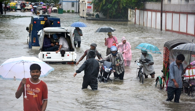
The recent floods in Agartala disrupted city life. (Photo by Tripurainfo.com)
A deluge on August 11 and 12 caught Agartala, the capital of Tripura in northeast India, completely unawares. Almost the entire city went under water, all urban services including local transportation came to a standstill. There were lives lost and property damaged.
Between 8 a.m. on August 10 and 8 a.m. on August 11, Agartala witnessed a total of 102.70 mm rainfall, India Meteorological Department data show. It was 93.90 mm in the next 24 hours. A total rainfall of 196.6 mm plunged the city under water and threatened its infrastructure.
Although the city is slowly recovering, it still faces the challenge of thwarting epidemics. Schools and colleges were closed for two days. Chief Minister Manik Sarkar, whose official residence was also flooded, had to take a bus to reach the State Secretariat, some 5 km away. The floods have rendered some 11,000 people homeless and resulted in four deaths till August 15.
Avoiding such urban calamities, which seems to be occurring in increasing frequency in cities across India, requires focused attention. In Agartala, they must centre on reviving the Haora river, once the lifeline of the city; modernising its drainage system; and restoring and preserving its rich natural ecosystem.
Extreme weather events
Agartala is unprepared for extreme weather events. The Greater Agartala Planning Area (GAPA) has expanded 30 times from 3 sq. km in 1901 to 92 sq. km in 2017. During the same period the population has increased 85 times to an estimated 550,000. Today, the population density of Agartala is about 6,000 people per sq. km.
Agartala, capital of the third smallest state in India, experiences an annual rainfall between 2,200 and 2,600 mm. Although heavy rainfall is par for the course, the intensity this year has had disastrous consequences, similar to the floods the city experienced in 1984 and 2004. But the magnitude of damage caused this year has been unprecedented.
Located only 12.80 metres above mean sea level, the future of the city is at great risk, and it is high time that measures are taken to create a road map for sustainable development of this historic city. Agartala, which is located just next to Bangladesh border, can also take lessons from that country in managing floods.
Bangladesh is considered one of the most vulnerable countries in the world to climate change effects, including sea level rise. “The location and geography of Bangladesh makes it not only particularly susceptible to the effects of climate change, but also extremely hard to protect,” researchers Mohammed Fazlul Karim and Nobuo Mimura wrote in the Global Environmental Change magazine.
It is likely that Tripura will also witness similar rainfall in increasing frequency in the coming years. There are many lessons to be learnt from this year’s floods on how to prepare to tackle such situations better. There are three measures that would go a long way to make Agartala a better-prepared and sustainable city.
Situational analysis
Agartala was established in 1849 by Krishna Kishore, then the king of Tripura. Two rivers flank the city — Katakhal in the north and Haora in the south, the latter with a much bigger catchment area. The ecosystem of the city has been strongly linked with these two rivers. Over a period of time, the carrying capacity of the Haora was reduced drastically because of deforestation and other construction activities in its catchment areas.
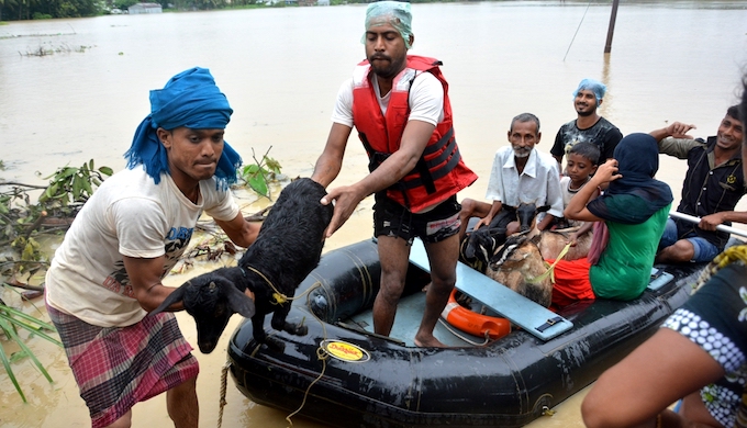
People and livestock had to be evacuated from the low lying areas of Agartala. (Photo by Tripurainfo.com)
On August 11, the embankment on the Hoara was damaged in two locations and all the water coming in from that river flooded the city, doubling the impact of rain-induced floods. All the rivers in Tripura flow into Bangladesh. This time, making things worse, neighbouring areas of Bangladesh also witnessed heavy rainfall and the water could not flow out of the city.
Increasing importance
In last few years Agartala has emerged as an important city in the region. It has highest air traffic in the northeast after Guwahati. India’s third international Internet gateway, after Mumbai and Chennai, was launched at Agartala last year by the Prime Ministers of India and Bangladesh.
Given the fact that surface connectivity to other parts of India from the northeast via Bangladesh is going to improve significantly, Agartala is going to be the nerve centre of all such developments. There are three factors that require immediate attention in the second most important city of northeast India.
Not without Haora: First and foremost, attention must be paid to the Haora river. Its water carrying capacity has been reduced drastically. However, it remains the lifeline of the city because about 60% of residents, particularly those living in the slums, depend on it for drinking water and other domestic usage. The river has a catchment area of about 414 sq. km and flows through a distance of 53 km. Reckless deforestation, extraction of sediment from the riverbed and construction of road and bridges have resulted in the swelling water coming inside the city with excessive rain.
Modernise city drainage: Agartala has a storm water drainage system about 60 km long. About 50% of the existing city area is covered by open drains. These drains carry sanitary wastes, which is discharged into the drains from septic tanks and toilets. During the monsoon, the situation worsens as the city is flooded by water from Haora and Katakhal. Then there is backflow from water bodies.
Pumping out the entire water out will be a Herculean task considering the magnitude of the floods. The need of the hour is widening and deepening the existing drains. Desilting of rivers and drains needs to be carried out along with aligning the drains for proper outflow of water. Widening the drains in and around the central part of the city and other market places needs to be taken up on a war footing.
Restore and preserve ecosystem: For years, there used to be a natural drainage connection between Katakhal and Deotachara, a tributary to Haora. This used to ensure free flow of water out of the catchment areas. Now due to construction of roads and buildings, this natural flow is disrupted affecting drainage.
The city and its peripheral areas had many lakes, ponds, other water bodies and marshy lands. These used to be the absorbent of storm water. Many such bodies got converted into habitat and commercial zones. A lake near Joynagar has disappeared over a period of time. The size of another prominent lake at College Tilla got drastically reduced. The areas like Kunjaban, Lichubagan in the north and Arundhuti Nagar and Amtoli in the south have witnessed degradation of natural resources due to construction activities and other human interventions.
These buffer zones are becoming more like concrete jungles, increasing the vulnerability of the city. Therefore the expansion of the city has to be planned in a more rational manner so that the absorbing capacity of the natural ecosystem is not compromised.
Biswanath Sinha is with Tata Trusts, overseeing its programmes in the eastern and northeastern parts of India. An engineer and development professional, he has earlier worked in Jharkhand and Uttarakhand. Views expressed are personal.